
Before the start
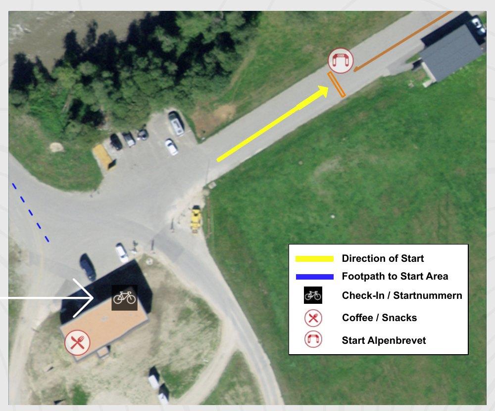
Check-in / race number pick-up
Friday, 4 September 2026, 15.00 – 21.00
Platin-, Gold-, Silber- & Bronzetour
Event location Andermatt
Saturday, 5 September 2026, 04.30 – 06.30
Platin-, Gold-, Silbertour
Event location Andermatt
Saturday, 5 September 2026, 07.30 – 08.45
Bronzetour
Event location Ulrichen
Please bring
Please show your registration confirmation when picking up your race number, or simply tell us your number!
At Friday’s check-in in Andermatt you can also, during the times listed above:
- get information about your booked accommodation.
- pick up your wristband for the pasta party or breakfast.
Friday evening: bar open
Our bar in the Event Village is open on Friday. Bring your friends for a pre-Alpenbrevet after-work beer!
Clothing pick-up
Orders from the Giordana clothing collection with on-site pick-up can only be collected in Andermatt at the Giordana stand during the following times.
- Friday, 4 September 2026, 15.00 – 20.00
- Saturday, 5 September 2026, 11.00 – 21.00
No clothing pick-up at the Bronzetour start in Ulrichen. All information regarding uncollected orders can be found in our order conditions.
Personal preparation
- Your bike is in technically perfect condition. Brakes, tyres, drivetrain, lights etc. have been checked.
- Reflectors on your bike: white at the front, red at the rear – mandatory under the road traffic regulations!
- Enough warm clothing for the descents
Mandatory lights
At the start of all tours, lights are mandatory – front (white) and rear (red) – until at least 09.00 and after 20.00 in the evening, as well as in conditions that reduce visibility (such as fog). Lights should not flash. To stay as visible as possible during the day, we recommend leaving your lights switched on.
No lights, no start
Lights are mandatory for all tours – otherwise you will not be allowed to start.
Technical support
Andermatt
- Sports shop: Imholz Sport Andermatt, Piazza Gottardo (Google Maps)
- Larger repair and service work is subject to a charge
- Spare material and accessories available for purchase
On the route
- There is a self-service station at every food station
- Minor repairs can be carried out on your own (no mechanics on site)
Mounting your race number
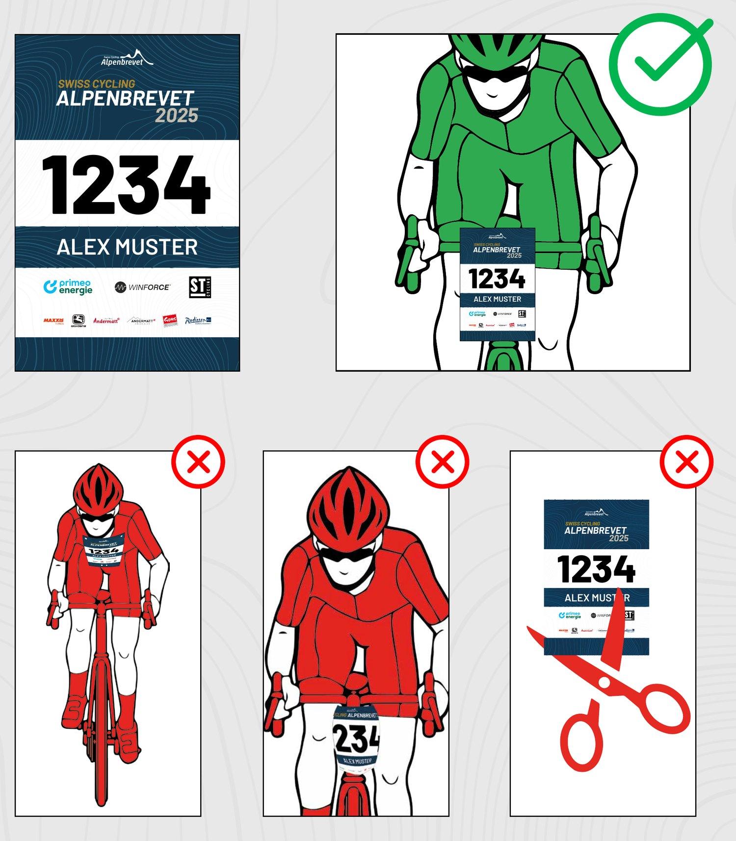
Fix your race number to the front of your handlebars so that it is clearly legible from the front. The number contains the transponder that records your split times. The race number must not be wrapped around the handlebars or the stem, and must not be cut down.
Frame sticker
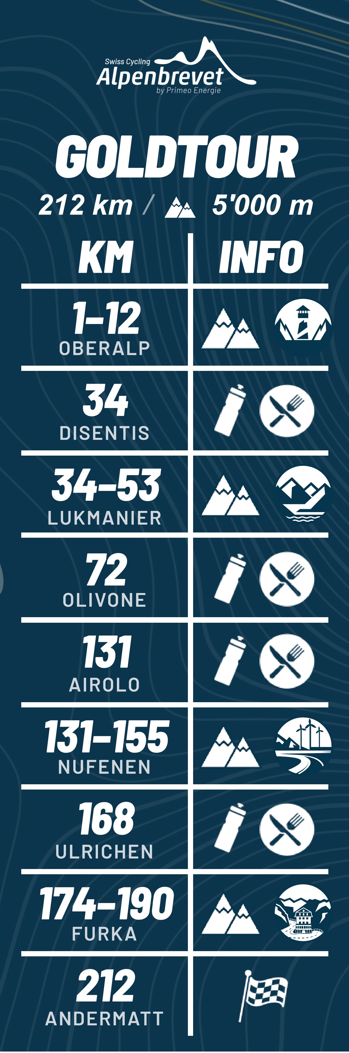
This year you will receive a sticker at race number pick-up showing all climbs and food stations. Attach it directly to your bike for the perfect overview along the way! The stickers are easy to remove.
Conduct on the route
To make sure you enjoy an unforgettable and safe Swiss Cycling Alpenbrevet 2026, we have compiled the most important information that applies to all tours.
Safety and rules
The Alpenbrevet is NOT A RACE
There are no rankings, no placings and nothing to win. The Alpenbrevet is a shared ride on open roads – ride in a way that gets you and everyone else safely back to Andermatt.
The Swiss Cycling Alpenbrevet takes place on open roads with regular traffic and is not a race. The following rules therefore apply at all times:
- Road traffic regulations apply at all times
- Always observe traffic lights and stop signs
- Never cross solid safety lines
- Never ride on the opposite lane
- Ride in single file
- Use cycle paths and lanes
- Make room for vehicles behind you
- Alpenbrevet participants behave in an exemplary, confident and courteous manner
- Lights and reflectors on the bike are mandatory
- Compliance with these safety-relevant points is checked by the police and official course marshals › non-compliance leads to disqualification and can lead to exclusion in future years
- Look after each other! Respect the other participants and the volunteers
- The instructions of moto marshals, officials and the police must be followed without restriction
- Event control must be informed immediately in the event of an accident
- No littering
- Urinating in the open countryside should be avoided where possible. Otherwise only in suitable places out of public view.
The complete rules, which apply to all registered participants, can be found here: alpenbrevet.ch/services/reglement/
Event ambulance | moto crew | broom wagon
Ambulance vehicles and moto marshals are out on the routes throughout the day. The instructions of security personnel (ambulance, police etc.) and official moto marshals must be followed at all times.
Treatment, transport costs and medical care are at the participants’ expense.
A broom wagon is on the road on every route. It travels so that the respective cut-off and finish times can be met. Riders behind the broom wagon are no longer entitled to the Alpenbrevet services. As a rule, the broom wagon does not pick up participants and bring them back to Andermatt. Where possible, it takes participants to the nearest railway station.
Shortening your tour or returning to Andermatt
If you are unable to finish your tour due to exhaustion, a crash or other reasons, you can shorten it at any time via a closer pass and return to Andermatt. Common shortcuts are:
- Platintour: from Gletsch via the Furka pass
- Gold- and Platintour: from Airolo via the Gotthard pass
Alternatively, you can return to Andermatt by public transport. You have the following options:
- From Ulrichen, the Matterhorn Gotthard railway runs to Andermatt
- From Airolo and Biasca, take the SBB train to Göschenen and from there the Matterhorn Gotthard railway to Andermatt
- From Disentis, the Matterhorn Gotthard railway runs to Andermatt
Important
Very last connection: the 20.15 bus from Disentis, Staziun/posta.
Timetables and tickets are available in the SBB timetable.
Don’t forget to check out
If you cannot finish your tour on the bike, please report to event control on +41 44 500 39 14.
Emergencies
All participants must carry a mobile phone. Event control must be able to reach you in an emergency.
In an emergency on the route, alert the Alpenbrevet event control (tel. +41 44 500 39 14) and, if necessary, one of the following emergency numbers:
Please also download the EchoSOS app to your mobile phone. In an emergency it shows you the most important emergency numbers in Switzerland and the hospitals near you.
You can find more about what to do in the event of an accident under point 7 of our rules.
Signage on the route
All routes are signposted at the key points with the following arrows.
At junctions and at places where several tours come together, stickers marking the respective tour are also in place.

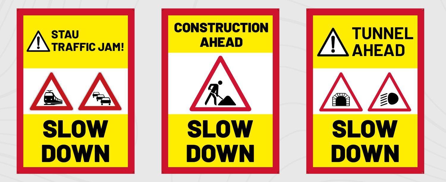
Spots requiring particular caution are marked with the following signs.
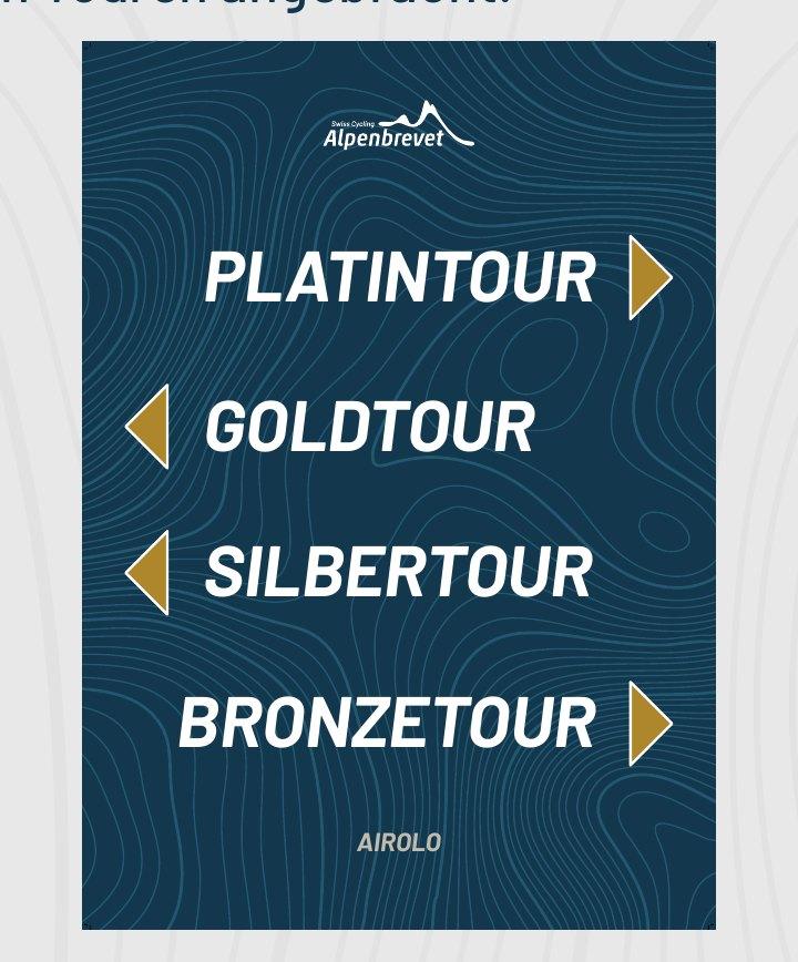
At the exit of each food station, boards show the directions of the individual tours.
Food stations & timing
Food stations
| Andermatt (start) |
Innertkirchen until 09.30 |
Ulrichen until 18.15 |
Airolo until 14.45 |
Olivone until 17.30 |
Disentis until 19.45 |
Andermatt (finish) until 21.00 |
|
|---|---|---|---|---|---|---|---|
| Winforce products* | |||||||
| Drinks | ✓ | ✓ | ✓ | ✓ | ✓ | ✓ | ✓ |
| Gels | ✗ | ✓ | ✓ | ✓ | ✓ | ✓ | ✗ |
| Bars | ✗ | ✓ | ✓ | ✓ | ✓ | ✓ | ✗ |
| Booster | ✗ | ✗ | ✓ | ✓ | ✓ | ✓ | ✗ |
| Beverages | |||||||
| Water | ✓ | ✓ | ✓ | ✓ | ✓ | ✓ | ✓ |
| Cola | ✗ | ✓ | ✓ | ✓ | ✓ | ✓ | ✗ |
| Bouillon | ✗ | ✓ | ✓ | ✓ | ✓ | ✓ | ✓ |
| Food | |||||||
| Bananas | ✗ | ✓ | ✓ | ✓ | ✓ | ✓ | ✓ |
| Oranges | ✗ | ✓ | ✓ | ✓ | ✓ | ✓ | ✓ |
| Apples | ✗ | ✓ | ✓ | ✓ | ✓ | ✓ | ✓ |
| Gherkins | ✗ | ✓ | ✓ | ✓ | ✓ | ✓ | ✓ |
| Bread | ✗ | ✓ | ✓ | ✓ | ✓ | ✓ | ✗ |
| Salt sticks | ✗ | ✓ | ✓ | ✓ | ✓ | ✓ | ✓ |
| Peanuts | ✗ | ✓ | ✓ | ✓ | ✓ | ✓ | ✓ |
| Biberli | ✗ | ✓ | ✓ | ✓ | ✓ | ✓ | ✓ |
| Chocolate | ✗ | ✓ | ✓ | ✓ | ✓ | ✓ | ✗ |
| Cheese | ✗ | ✗ | ✓ | ✓ | ✓ | ✓ | ✗ |
Swipe sideways to see the whole table.
* Standard: Carbo Basic Plus, Ultra Energy Complex, Panforte Riegel, Oat Bite.
Additional: Booster, Hydro Energy, Fast Nutrition Stick.
Toilets are available at all stations. There are also first aiders at every station.
Play fair
There is enough for everyone, but please remember that the last riders will also be glad to grab a bar or a banana.
The exact locations of the food stations are marked on the respective route maps. The stations are also signposted along the route.
Timing
Timing also takes place at the food stations listed above. To record your time, ride over the timing mat or through the light barrier. Timekeeping uses the transponder in your race number.
At the end, your personal diploma and the results list on our website will show your times for all pass climbs and your total tour time. There will be no ranking.
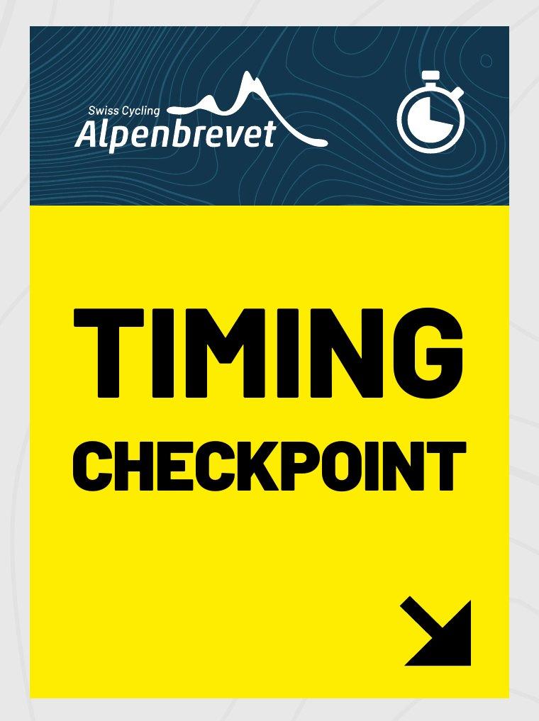
The timing points are marked with the following board.
Exception Platintour
The first section from Andermatt to Wassen is neutralised and takes place behind the official moto marshals. The time for the climb to the Susten pass is taken in Wassen.
Finish in Andermatt
1st-Time Finisher Bell
Finishing the Alpenbrevet for the first time? Then ring the 1st-Time Finisher Bell in the finish area – your moment, your sound, your first Alpenbrevet.
Finisher shirt & race number deposit
After crossing the finish line, our volunteers will remove your race number from your bike. You then have three options:
- Keep your race number as a souvenir
- Exchange your race number for an Alpenbrevet shirt in the event tent
- Get your CHF 10 race number deposit back in cash in the event tent
Finisher medal
If you ordered a medal in advance, you will receive it right after crossing the finish line.
If you would like to buy a medal on site, you can still do so in the event tent for CHF 10.
Finisher bag
At the end of the Alpenbrevet, all participants receive a finisher bag with great goodies from our partners. It can be picked up in the event tent (check-in) after the finish.
Your finisher bag also contains a voucher for your finisher beer – redeem it in the Event Village.
Event Village
After the Alpenbrevet, various partner stands and a wide range of food await you in the Event Village.
Massage
Free massage service, no advance booking needed, in the multi-purpose hall.
All finishers are winners
There are no rankings with placings and no award ceremonies.
Personal certificate
Your finisher certificate will be sent to you by e-mail after the finish.
Personal photos
Sportograf is the official event photographer of the Swiss Cycling Alpenbrevet 2026. Your personal photos will be available via Sportograf within a few days of the event and can be purchased.
Personal video
SWICA creates a personal Alpenbrevet video, the «SWICA Race Moment», for riders of the Swiss Cycling Alpenbrevet. The video is free of charge for all participants and will be published on the SWICA website at swica.ch/finisher-clip. Participants will receive an e-mail with a link to their video after the event.
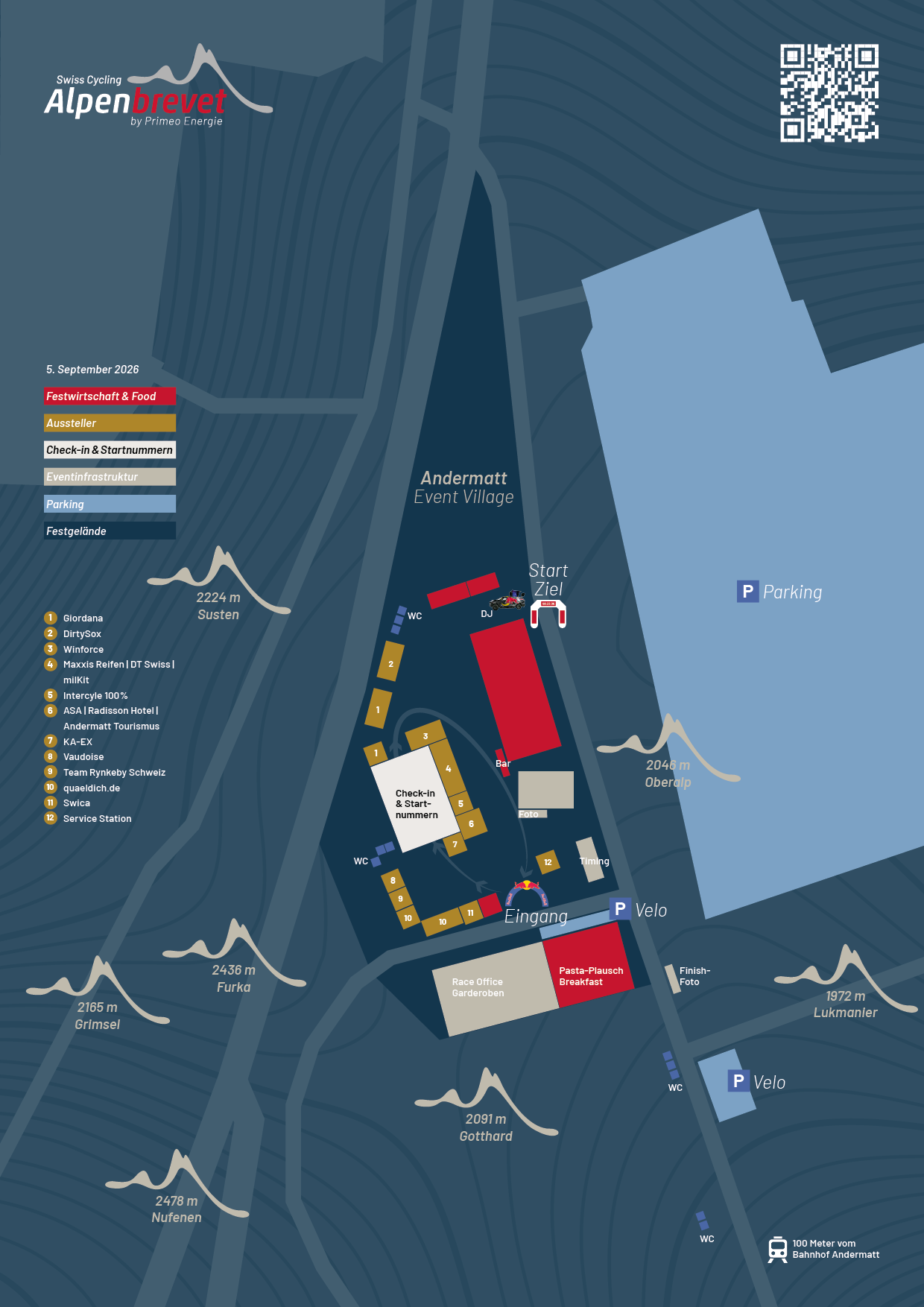
Site plan Andermatt
Event Village Andermatt, 5 September 2026
At the event grounds
- Festival catering & food
- Exhibitors
- Check-in & race numbers
- Event infrastructure
- Parking
- Event grounds
Also on site: race office, changing rooms, pasta party, breakfast, bar, DJ, photo, finish photo, timing, WC as well as parking for cars and bikes. The Event Village is around 100 metres from Andermatt railway station.
Exhibitors
- Giordana
- DirtySox
- Winforce
- Maxxis Reifen | DT Swiss | milKit
- Intercyle 100%
- ASA | Radisson Hotel | Andermatt Tourismus
- KA-EX
- Vaudoise
- Team Rynkeby Schweiz
- quaeldich.de
- Swica
- Service Station
Platintour
Mass start at 5.45
The section from Andermatt to Wassen is neutralised and therefore not timed. Moto marshals accompany the participants. Overtaking is prohibited and lights are mandatory!
11.45 in Ulrichen · 13.45 in Airolo
Anyone arriving in Ulrichen or Airolo after these times must ride to Andermatt by the fastest possible route.
21.00 in Andermatt – must be strictly observed.
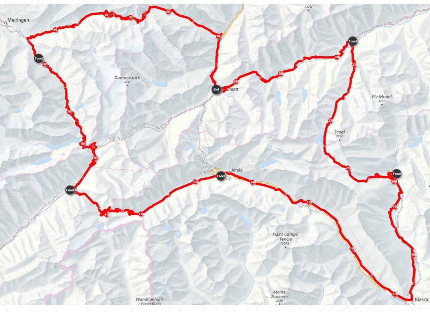
On the route map you can download the route as a GPX file via «Download GPX». On the mobile version, tap the information (i) icon first.
Sustenpass from Wassen
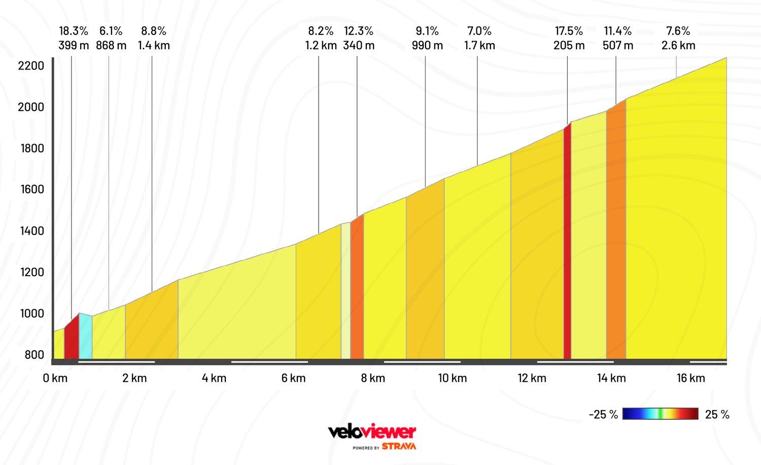
Take particular care at these spots
- Three tunnels shortly after the start of the climb from Wassen (lights mandatory, single file)
- Tunnel before the summit (lights mandatory, single file)
- Several shorter unlit tunnels in the upper part of the descent towards Innertkirchen (lights mandatory, single file)
- Tunnel shortly after Gadmen (lights mandatory, single file)
- Tunnel shortly before Innertkirchen (lights mandatory, single file)
- Junction with level crossing in Innertkirchen → slow down!
- Roadworks are possible at any time along the route. At construction sites controlled by traffic lights → red light = stop! No discussion.
- Approach construction sites with caution → observe the signs. A dirty road surface or a suddenly stationary line of vehicles considerably reduces your stopping distance.
Grimselpass from Innertkirchen
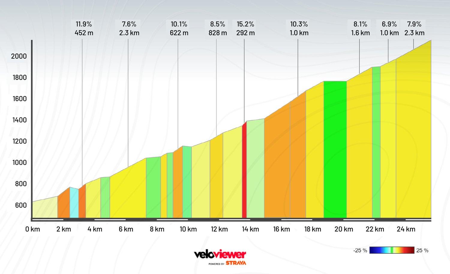
Take particular care at these spots
- Several tunnels between the food station at Restaurant Urweid and the Räterichsboden reservoir (lights mandatory, single file)
- Longer tunnel shortly before the Räterichsboden reservoir → bicycles prohibited in the tunnel! You must use the signposted bypass!
- Junction Grimselstrasse/Furkastrasse in Gletsch → slow down!
- Level crossing in Gletsch – caution!
- Cobbled tunnel in the upper part of the descent between Gletsch and Oberwald (lights mandatory, single file)
- Roadworks are possible at any time along the route. At construction sites controlled by traffic lights → red light = stop! No discussion.
- Approach construction sites with caution → observe the signs. A dirty road surface or a suddenly stationary line of vehicles considerably reduces your stopping distance.
Nufenenpass from Ulrichen
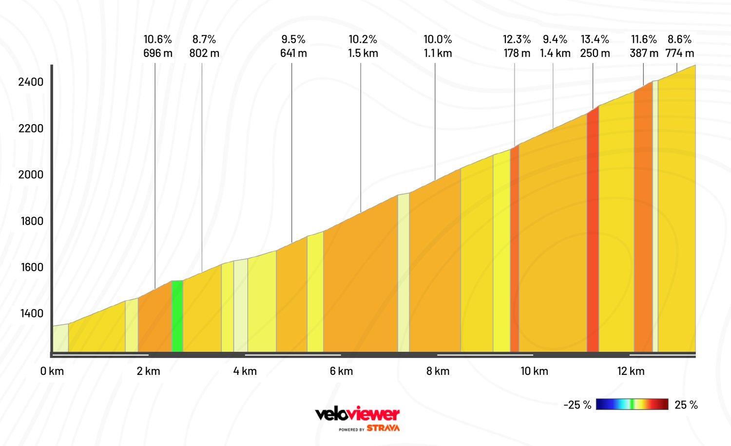
Take particular care at these spots
- All tours cross the Nufenen pass → beware of oncoming riders!
- Level crossing before the Ulrichen food station → slow down!
- Tunnel shortly after Airolo towards Biasca (lights mandatory, single file)
- Tunnel after Rodi-Fiesso towards Biasca (lights mandatory, single file)
- Roadworks are possible at any time along the route. At construction sites controlled by traffic lights → red light = stop! No discussion.
- Approach construction sites with caution → observe the signs. A dirty road surface or a suddenly stationary line of vehicles considerably reduces your stopping distance.
Lukmanierpass from Biasca
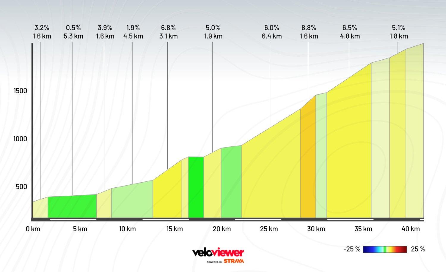
Take particular care at these spots
- Follow the route through Biasca → through the town and not on the expressway
- Follow the route after Biasca → side road and cycle path, not the main road towards Olivone
- Three shorter galleries between the food station in Olivone and the summit (lights mandatory, single file)
- Long tunnel shortly after the summit along the reservoir (lights mandatory, single file)
- Several galleries in the upper part of the pass on the descent towards Disentis (lights mandatory, single file)
- Several tunnels between Curaglia and the Disentis food station (lights mandatory, single file)
- Roadworks are possible at any time along the route. At construction sites controlled by traffic lights → red light = stop! No discussion.
- Approach construction sites with caution → observe the signs. A dirty road surface or a suddenly stationary line of vehicles considerably reduces your stopping distance.
Oberalppass from Disentis
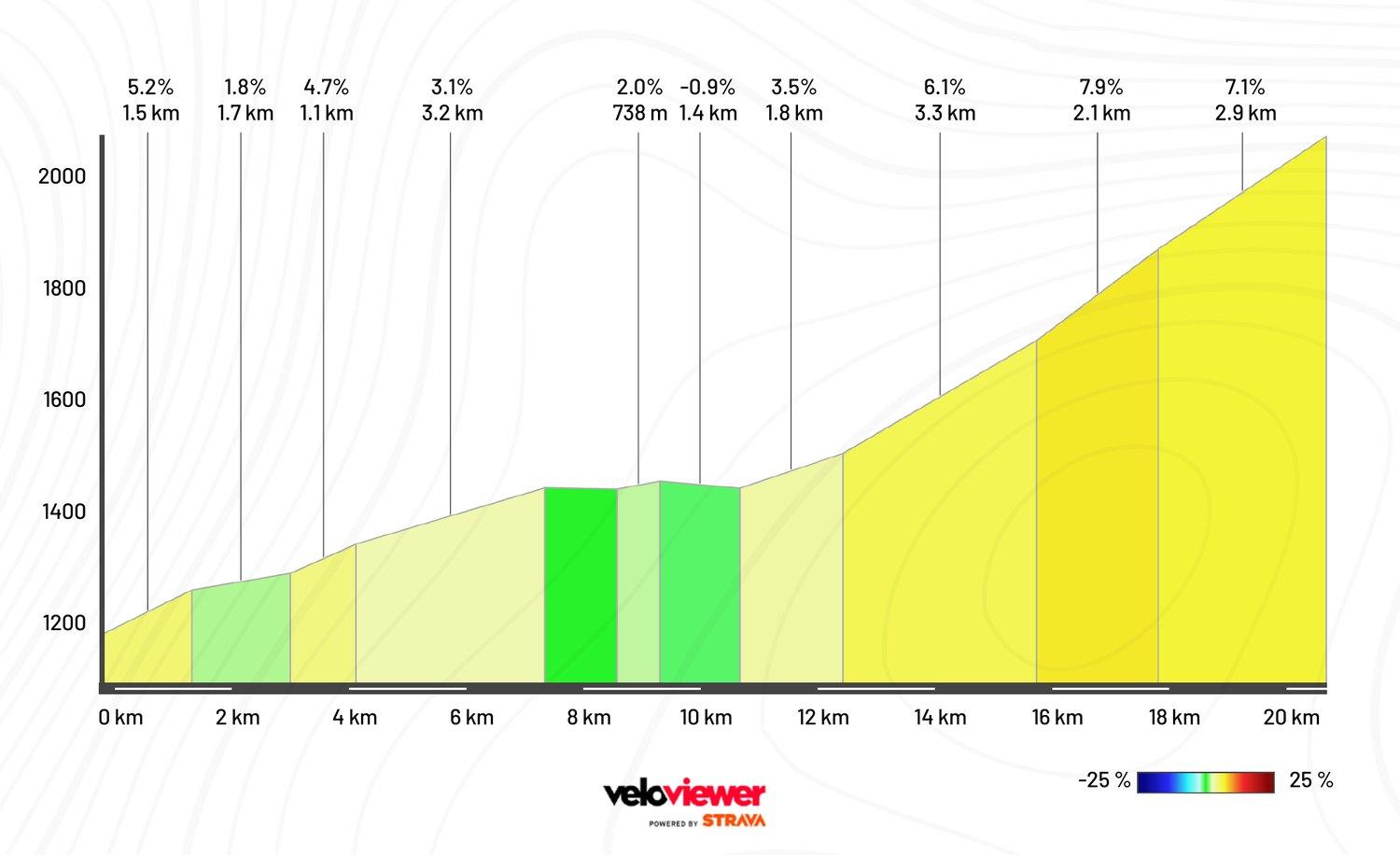
Take particular care at these spots
- Tunnel before Tujetsch (lights mandatory, single file)
- Long gallery shortly after the summit on the descent towards Andermatt (lights mandatory, single file)
- Tunnel in the final hairpins between Nätschen and Andermatt (lights mandatory, single file)
- Roadworks are possible at any time along the route. At construction sites controlled by traffic lights → red light = stop! No discussion.
- Approach construction sites with caution → observe the signs. A dirty road surface or a suddenly stationary line of vehicles considerably reduces your stopping distance.
Goldtour
Mass start at 06.00
14.00 in Airolo. Anyone arriving in Airolo after this time must ride to Andermatt by the fastest possible route.
21.00 in Andermatt – must be strictly observed.
On the route map you can download the route as a GPX file via «Download GPX». On the mobile version, tap the information (i) icon first.
Oberalppass from Andermatt
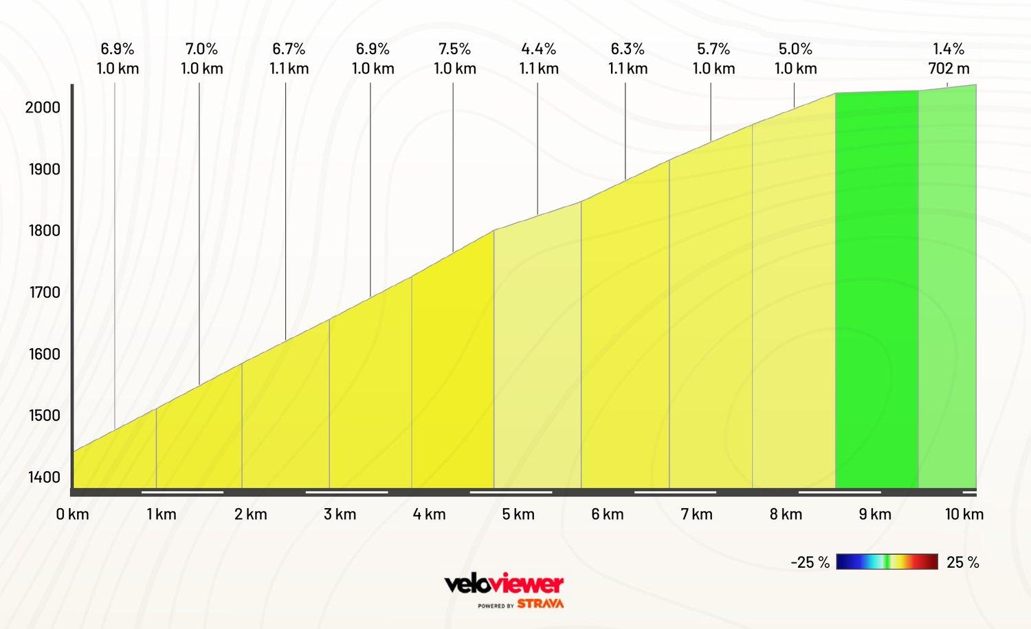
Take particular care at these spots
- Tunnel in the first hairpins between Andermatt and Nätschen (lights mandatory, single file)
- Long gallery shortly before the summit towards Disentis (lights mandatory, single file)
- Tunnel after Tujetsch (lights mandatory, single file)
- Junction in Disentis with right turn towards the Lukmanier pass → slow down!
- Roadworks are possible at any time along the route. At construction sites controlled by traffic lights → red light = stop! No discussion.
- Approach construction sites with caution → observe the signs. A dirty road surface or a suddenly stationary line of vehicles considerably reduces your stopping distance.
Lukmanierpass from Disentis
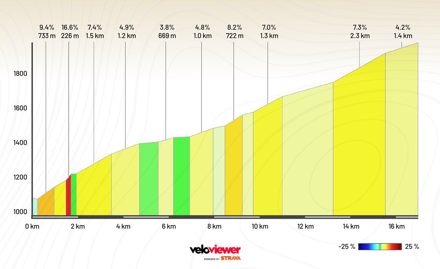
Take particular care at these spots
- Several tunnels between the Disentis food station and Curaglia (lights mandatory, single file)
- Several galleries in the upper part of the pass (lights mandatory, single file)
- Long tunnel shortly before the summit along the reservoir (lights mandatory, single file)
- Three shorter tunnels between the summit and the food station in Olivone (lights mandatory, single file)
- Damaged road surface on the descent between the summit and the food station in Olivone.
- Follow the route through Biasca → through the town and not on the expressway.
- Roadworks are possible at any time along the route. At construction sites controlled by traffic lights → red light = stop! No discussion.
- Approach construction sites with caution → observe the signs. A dirty road surface or a suddenly stationary line of vehicles considerably reduces your stopping distance.
Nufenenpass from Airolo
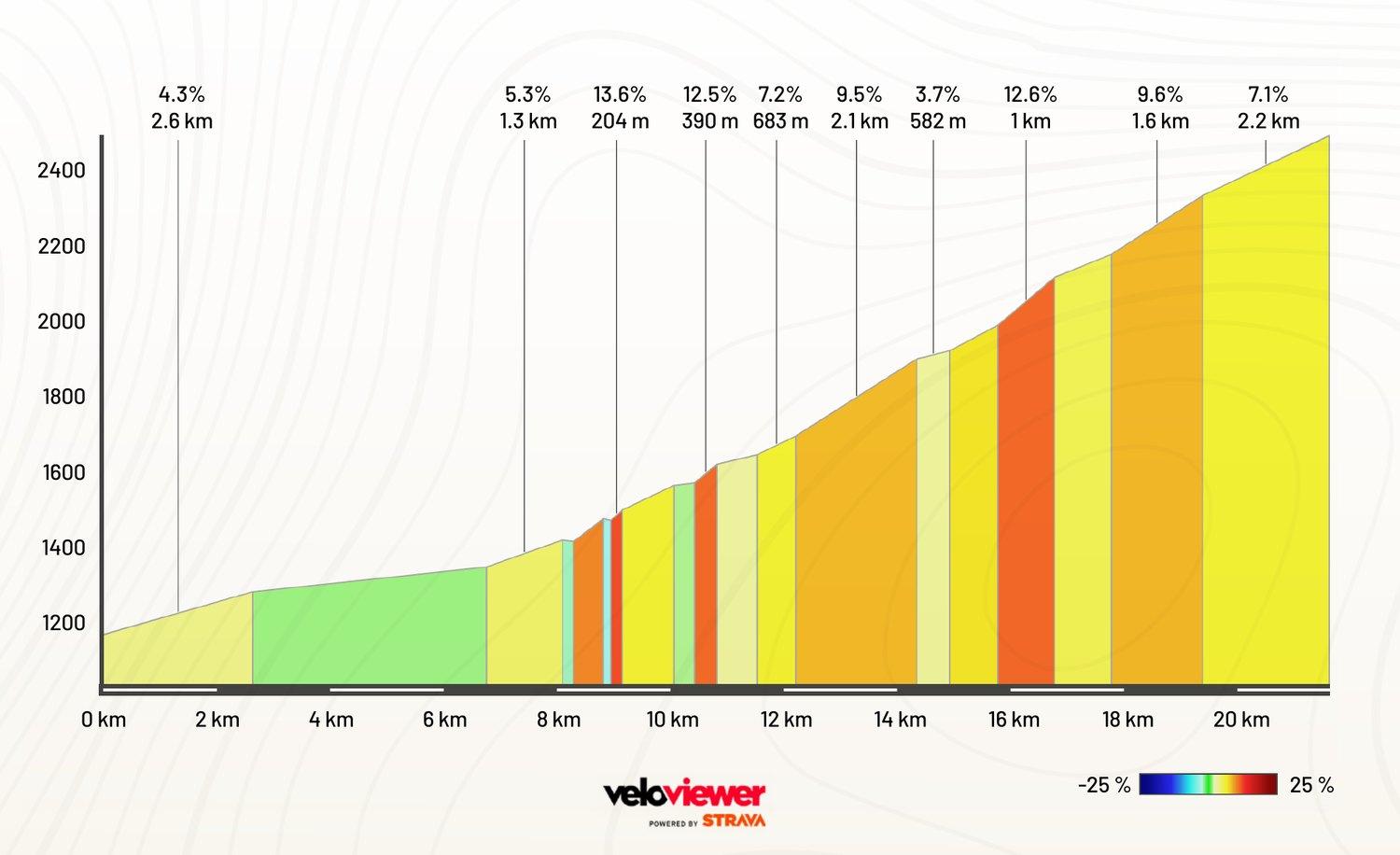
Take particular care at these spots
- All tours cross the Nufenen pass → beware of oncoming riders!
- Tunnel before Rodi-Fiesso towards Airolo (lights mandatory, single file)
- Tunnel shortly before Airolo (lights mandatory, single file)
- Level crossing after the Ulrichen food station → slow down!
- Roadworks are possible at any time along the route. At construction sites controlled by traffic lights → red light = stop! No discussion.
- Approach construction sites with caution → observe the signs. A dirty road surface or a suddenly stationary line of vehicles considerably reduces your stopping distance.
Furkapass from Oberwald
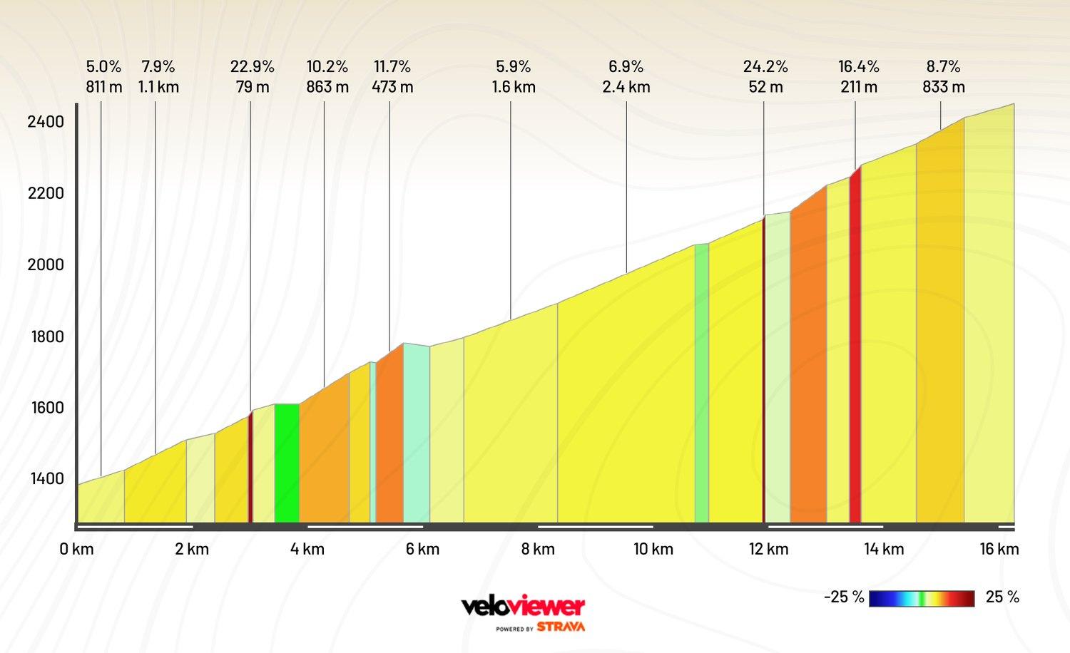
Take particular care at these spots
- Short cobbled tunnel in the lower part of the climb between Oberwald and Gletsch
- Level crossings at the entrance and exit of Gletsch towards the summit → slow down!
- Level crossing shortly before the bridge over the Muttbach towards the summit → slow down!
- Partly narrow roads on the descent as far as Realp
- Level crossing at Zumdorf towards Andermatt → slow down!
- Roundabout in Hospental at the end of the descent
- Roadworks are possible at any time along the route. At construction sites controlled by traffic lights → red light = stop! No discussion.
- Approach construction sites with caution → observe the signs. A dirty road surface or a suddenly stationary line of vehicles considerably reduces your stopping distance.
Silbertour
Mass start at 06.25
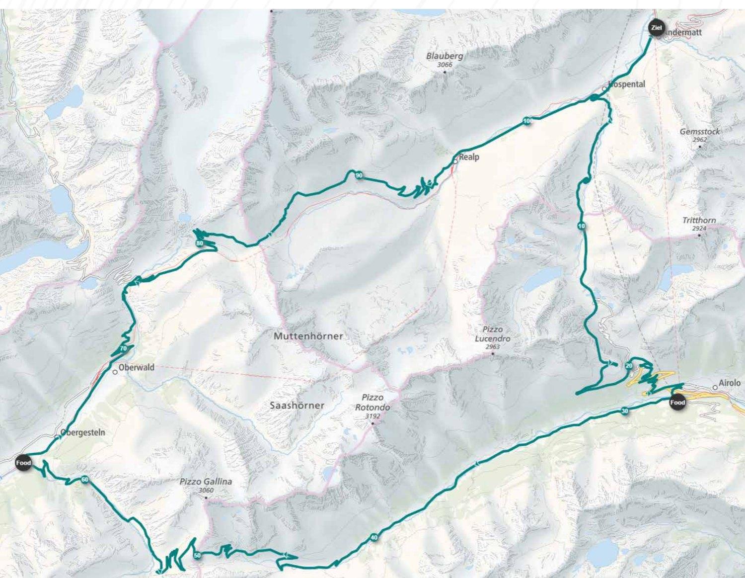
The descent from the Gotthard pass to Airolo follows the main road as far as Motto Bartola. From there the route switches to the old pass road, because bicycles are prohibited. Observe the signage on site!
None
21.00 in Andermatt – must be strictly observed.
On the route map you can download the route as a GPX file via «Download GPX». On the mobile version, tap the information (i) icon first.
Gotthardpass from Hospental
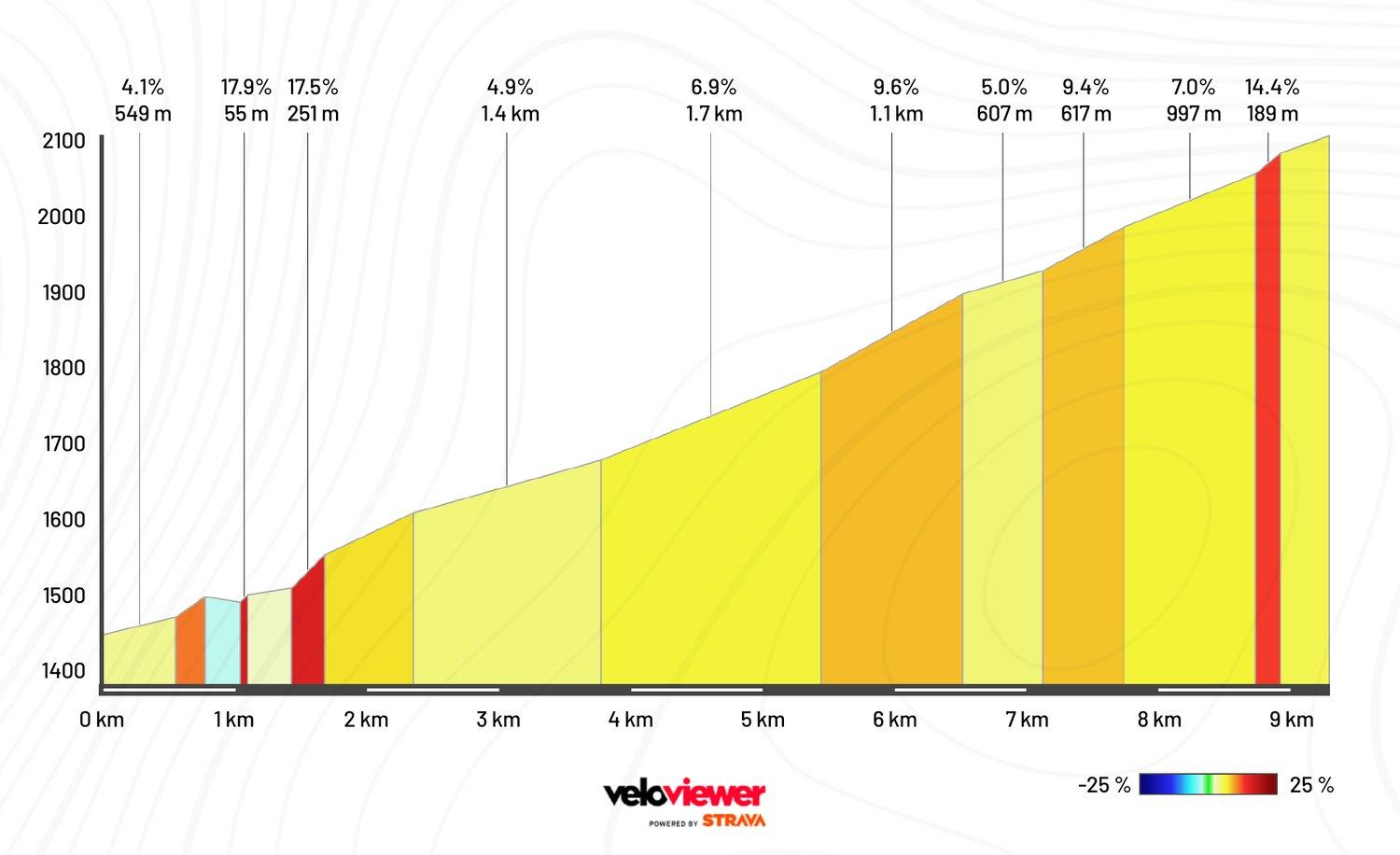
Take particular care at these spots
- Gallery shortly before the summit (lights mandatory, single file)
- Shortly after the summit, on the descent towards Airolo, a long gallery is followed by a tunnel (lights mandatory, single file).
- The surface in these two tunnels is adequate but not perfect → slow down!
- Gallery shortly before the Motto Bartola exit (lights mandatory, single file)
- Right turn in Motto Bartola from the main road onto the old pass road
- A total of four cobbled sections in the lower part of the descent towards Airolo → slow down!
- Roadworks are possible at any time along the route. At construction sites controlled by traffic lights → red light = stop! No discussion.
- Approach construction sites with caution → observe the signs. A dirty road surface or a suddenly stationary line of vehicles considerably reduces your stopping distance.
Nufenenpass from Airolo
Take particular care at these spots
- All tours cross the Nufenen pass → beware of oncoming riders!
- Level crossing after the Ulrichen food station → slow down!
- Roadworks are possible at any time along the route. At construction sites controlled by traffic lights → red light = stop! No discussion.
- Approach construction sites with caution → observe the signs. A dirty road surface or a suddenly stationary line of vehicles considerably reduces your stopping distance.
Furkapass from Oberwald
Take particular care at these spots
- Short cobbled tunnel in the lower part of the climb between Oberwald and Gletsch
- Level crossings at the entrance and exit of Gletsch towards the summit → slow down!
- Level crossing shortly before the bridge over the Muttbach towards the summit → slow down!
- Partly narrow roads on the descent as far as Realp
- Level crossing at Zumdorf towards Andermatt → slow down!
- Roundabout in Hospental at the end of the descent
- Roadworks are possible at any time along the route. At construction sites controlled by traffic lights → red light = stop! No discussion.
- Approach construction sites with caution → observe the signs. A dirty road surface or a suddenly stationary line of vehicles considerably reduces your stopping distance.
Bronzetour
08.45 / 8.50 / 8.55 in groups of 80 participants
Start location Ulrichen
None
21.00 in Andermatt – must be strictly observed.
On the route map you can download the route as a GPX file via «Download GPX». On the mobile version, tap the information (i) icon first.
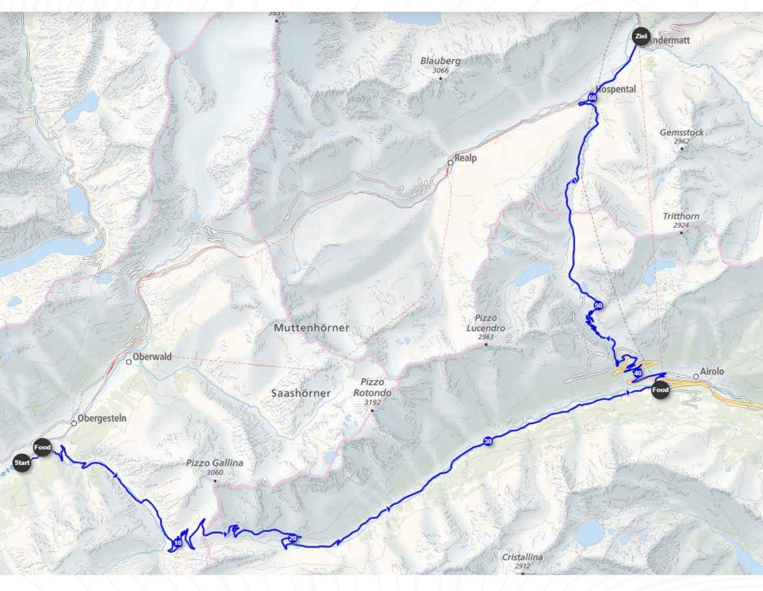
Nufenenpass from Ulrichen
Take particular care at these spots
- All tours cross the Nufenen pass → beware of oncoming riders!
- Level crossing before the Ulrichen food station → slow down!
- Roadworks are possible at any time along the route. At construction sites controlled by traffic lights → red light = stop! No discussion.
- Approach construction sites with caution → observe the signs. A dirty road surface or a suddenly stationary line of vehicles considerably reduces your stopping distance.
Gotthardpass from Airolo
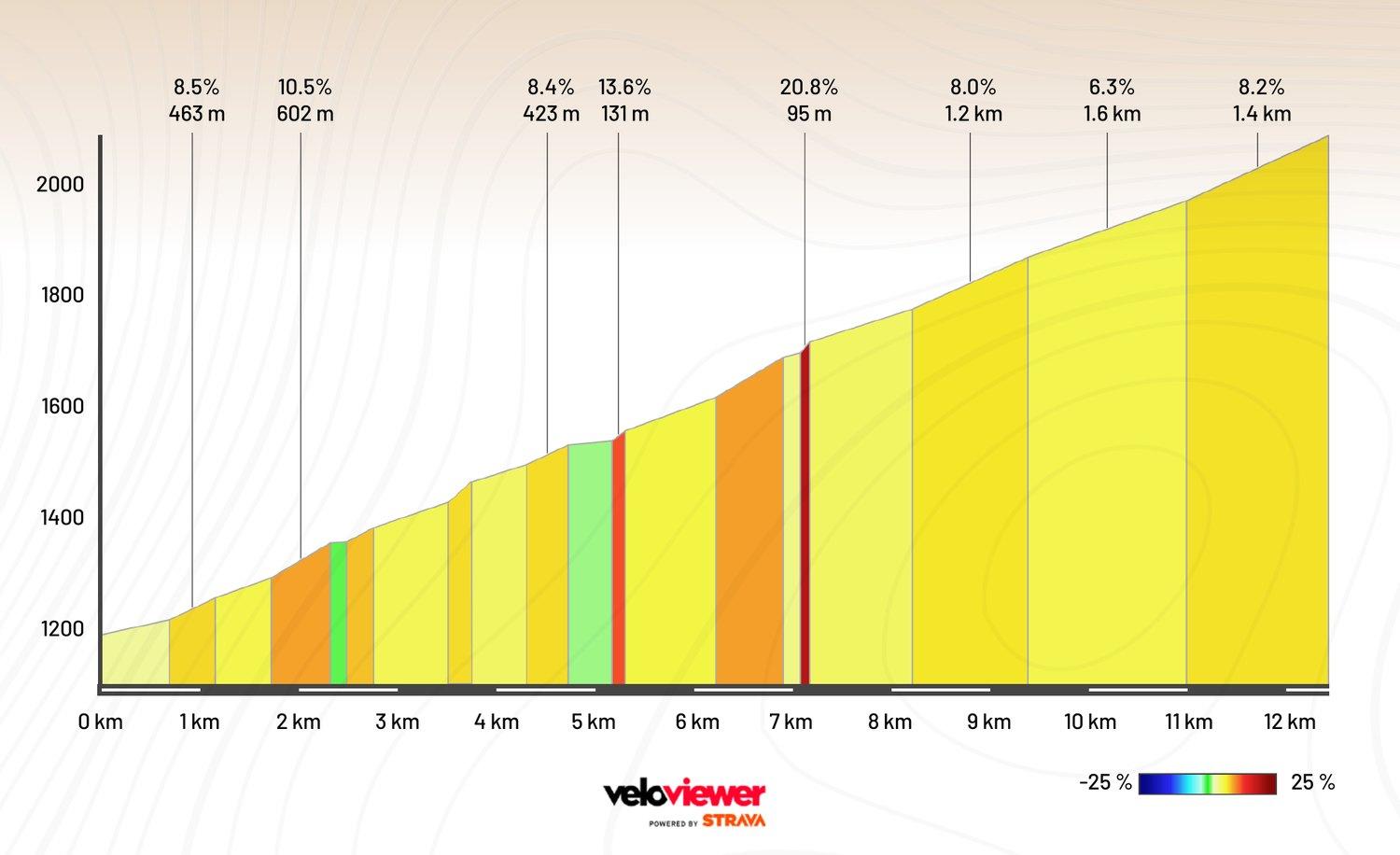
Take particular care at these spots
- A total of four cobbled sections in the lower part of the climb up to Motto Bartola
- Continuous cobblestones on the second half of the climb (Tremola)
- At the summit, turn onto the main road (follow the signage)
- Gallery shortly after the summit on the descent towards Hospental (lights mandatory, single file)
- Roundabout in Hospental at the end of the descent
- Roadworks are possible at any time along the route. At construction sites controlled by traffic lights → red light = stop! No discussion.
- Approach construction sites with caution → observe the signs. A dirty road surface or a suddenly stationary line of vehicles considerably reduces your stopping distance.
A big thank you to all partners and suppliers!
Presenting Partner

Premium Partner


Partner







Supplier











Media Partner

Partner-Event



Institutional Partner



Proud Member of